NORTH SMITHFIELD – If you’ve lived in North Smithfield for at least a few years, you’ve likely heard a thing or two about the town’s rich history, and you may even know the facts surrounding one or two significant sites.
But what you may not know is that between former mill houses, cemeteries, landmarks, private homes and more, North Smithfield has more than 100 locations with historical significance.
Now, thanks to the North Smithfield Heritage Association with the help of work by both students and adult volunteers, the information is accessible in an instant, and can be used by residents for virtual tours, research and more.
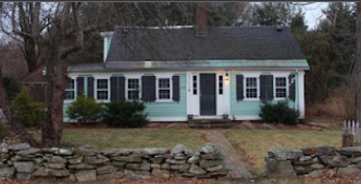
The NSHA has created a public database of the town’s historic sites, complete with photos and background information on former mills, stone features and conservation areas.
“We’ve recognized the need for virtual tours for years,” explained NSHA President Richard Keene. “The challenge was always finding the time to get to it.”
The effort to finally document the sites for public use began several years ago when resident Christopher Serrano created a custom file of many using Google Maps.
“I was able to download datasets from RIGIS.org including historical cemeteries, historical areas, and conservation areas,” said Serrano. “This data is available free to all and can be downloaded in KML file format, which is a universal file format used for maps.”
Serrano handed his initial work over to the association.
“Of course, Rich found that a lot of updating could be done using local Cemetery Commission info,” he said.
Keene added the commission’s cemetery information, then updated it further using photos and data from NSHA’s records.
The association members then turned their attention to the town’s historic buildings, by creating layers for each existing and potential historic district.
“The RI Historic Preservation and Heritage Commission conducted a preliminary survey of the town in 1980 that provides descriptions of 104 historic buildings and structures,” Keene explained.
In 2021, North Smithfield High School student Ryan Walsh began working on adding the Primrose District portion to the map as part of his senior project.
“He uploaded his own photos and used some of ours as well as the RIHPHC data,” Keene said.
And just recently, Lincoln High School student Hannah Tillson moved the project forward to complete part of her National Honor Society requirements.
“She took it over the top,” Keene said.

The map allows users to display sites by district, or to focus strictly on cemeteries. A click on the entry for Cobble Rock immediately displays a photo of the large boulder.
“A large granite boulder, or glacial erratic, on a bedrock of mica slate in a wooded area near the Woonsocket city-line. The area was formerly a scythe-stone quarry,” the entry notes. “Cobble Rock has long been regarded as a geological curiosity. It is noted in Jackson’s 1339 geological report and in a 19th-century newspaper article and appears on many early 20th-century postcards. Long perched in a precarious-looking position, the rock was knocked over in the late l97Os.”
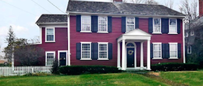
A click on the Joel Aldrich house in Union Village brings up this entry:
“A 2½-story, 5-bay, Federal house, with two interior, end-wall chimneys. The central entry, with an elliptical fanlight, is surrounded by rustication. The delicate pedimented portico, very like that of the Daniel Arnold House, is highly regarded. There is a 2-story lateral ell. The Aldrich House is one of the finest early 19th-century houses in Union Village. The building was used for a time as a dormitory for the Linden Grove Seminary, a school for young ladies, before the school moved to Pawtucket in the l85Os.”
Keene said the group still plans to add more landmarks and descriptive data. He thanked who helped over the past several years to make the project a reality.
“This was a great start,” Keene said. “The public can conduct their own virtual tour from their home or while walking, biking and driving.”
The full map of all historic sites located by the NSHA as of 2021 can be viewed here.


